Katie Bonnell Park Environmental Report
The information provided here is in response to the Montana Department of Environmental Quality (DEQ) request for environmental data pertaining to the Katie Bonnell Park Area. This response follows DEQ's request, articulated in a letter dated August 23, 2023, and through subsequent discussions, for maps and data summary tables highlighting Facility sample locations around two specific properties: Katie Bonnell Park and 1310 E Gallatin St. The requested tables cover a range of data including surface soil, subsurface soil, indoor air, soil gas, and groundwater. We detail the relevant information from the submitted reports as follows:
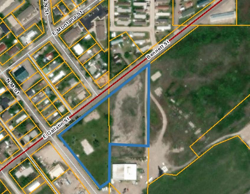
Soil: Our records show no evidence of surface or subsurface soil samples being collected from the Katie Bonnell Park property. However, subsurface soil samples were taken from 1310 E Gallatin St and the Cinder Pile area, situated over 250 feet south-southeast of Katie Bonnell Park. Summarized below is the soil sample data relevant to DEQ's request:
- Samples around the Cinder Pile, part of the 1994 Remedial Investigation (RI) Report, are detailed in Tables 3.8, 3.16, 3.22, 3.23, and 3.27, and depicted in Figures 3.16, 3.17, and 3.31.
- The 2012 2nd Revised Task J Surface Soil Supplemental Investigation Report presents soil data near Katie Bonnell Park. This data is summarized in Table 8 and illustrated in Figures 16B and 16C. Table 8 includes Record of Decision (ROD) Cumulative Update Limits (CULs) or applicable screening levels for certain constituents.
- Water and Environmental Technologies (WET) collected soil samples around the Cinder Pile, as reported in their March 2021 Cinder Pile Remedial Design Study Report. The data are consolidated in Table 2 and shown in Figures 6 to 11 of the report. These samples were collected outside the 100-foot buffer zone for Volatile Organic Compounds (VOCs) and mixed plumes, as per the Montana Vapor Intrusion Guide (2021).
Soil Gas & Indoor Air: Soil gas and indoor air samples were taken from several locations around Katie Bonnell Park, including 1310 E Gallatin Street, but not within the Katie Bonnell Park boundary. Most samples were collected outside the 100-foot VOCs and mixed plumes buffer zone. The relevant data includes:
- Samples from properties west-southwest of Katie Bonnell Park, as part of the 1994 RI investigation. Results are in Tables 6.11, 6.12, 6.19, and 6.22, and Figures 6.3 and 6.8.
- The 2016 Revised Task I Supplemental Investigation Report summarizes soil gas and indoor air samples. Results are in Table 2, with locations shown in Figures 2 and 3. DEQ, in a letter dated September 29, 2017, approved this report, deeming no further action necessary. Table 2 includes specific cleanup levels for residential and industrial indoor air.
- WET's 2014 investigation results, documented in their March 2021 report, are summarized in Table 1 and depicted in Figures 5 to 11. Although soil gas levels exceeded indoor air screening criteria, DEQ concluded no further action was necessary.
Groundwater: The most recent groundwater data appears in the Combined 2022/2023 Annual Monitoring and Maintenance Report for the Burlington Northern Livingston Shop Complex, Livingston, Montana. Monitoring wells near, but not on, the Katie Bonnell Park property have provided data summarized in Table 21 and depicted in Figures 18 and 19. Historical well data is in Appendix B, including ROD CULs and MT DEQ-7 groundwater standards.
For a detailed review, please refer to the specific sections in the mentioned reports attached below.